2025 ASAP Annual Safety Overview
2025 ASAP Safety Overview & Analysis
In 2025 Air Charter Safety Foundation recorded 1458 events and 2079 reports in its Aviation Safety Action Program (ASAP). The data shows that human factors continue to define the safety landscape. Overall trend indicates reduction in event/report volume year-to-year showing encouraging signs of effective safety mitigations and corrective actions by our members. In 2026, we will continue to monitor, as well as enhance, or trending of reporting volume to ensure that “Reporting Fatigue” is not a factor. Despite several high-profile incidents in the past year, number of overall accidents in both General and Commercial Aviation are on downward trend over the past 20 years, despite a continuous increase in flight hours.
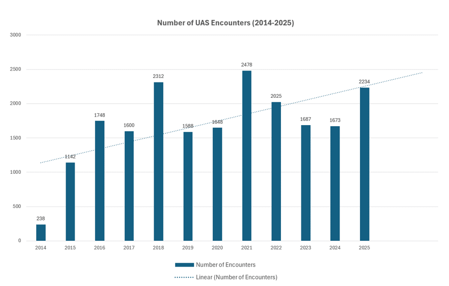
Nevertheless, it is vital to continue strengthening safety culture while heeding industry changes and emerging risks. With global instability hot zones (Middle East, Black Sea & Easten Europe, Baltic Sea & Northern Europe, South America), GPS/GNSS spoofing and interference is on the rise due to military activity. Unmanned Aerial Systems (both civilian and military) pose an increasing risk as well. Between 2014 and 2025 FAA recorded drone incursions into controlled airspace increase from few hundred to multiple thousands per year. This trend reflects both increase in drone encounters and improved reporting culture.
FAA has issued Safety Alerts for Operators (SAFOs) regarding GPS/GNSS disruptions, and Unmanned Aircraft Systems Detection and Mitigation Systems report for drone encounters, giving guidance to flight crews and operators on how to recognize and mitigate these occurrences.
ASAP
REQUEST ASAP
Events from two years ago refer to those submitted between October 1, 2022, and September 30, 2023, while last year covers October 1, 2023, to September 30, 2024. The data is organized this way for FAA reporting purposes.
UAS Encounters
The use of big data analytics is expanding to improve safety management systems. By collecting and analyzing flight data, operators can identify patterns of behavior that could indicate safety risks. This data can be used to refine training programs, update maintenance schedules, and predict failures before they occur, ultimately reducing incidents and improving operational safety.
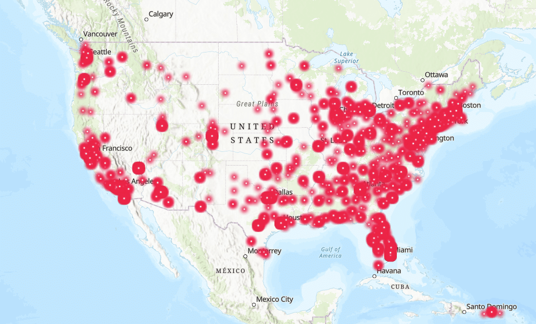
2025 UAS Encounters Map
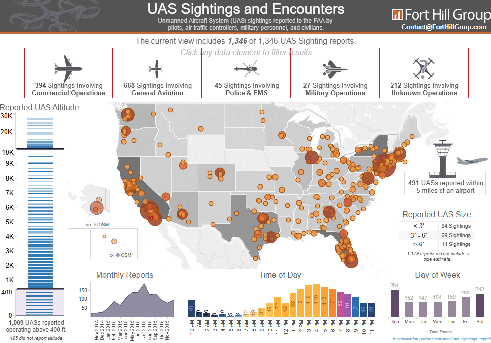
UAS Sightings and Encounters
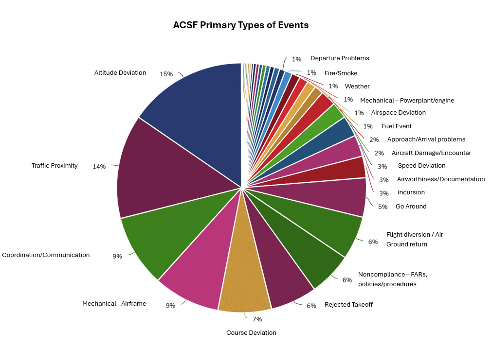
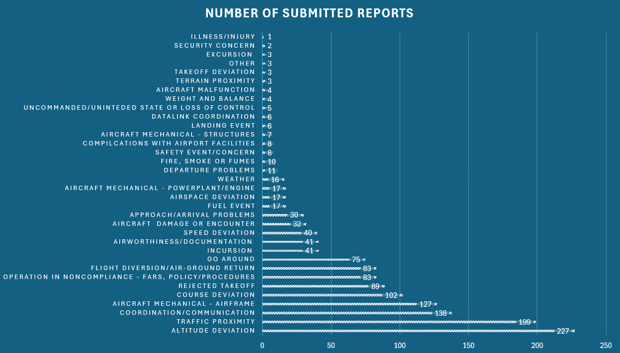
Primary Type of Events
Human factors continue to be primary root cause of reports received at ACSF. Communication issues, Altitude Deviations and Course Deviations combined comprise 31% (467 reports) of all reports. This indicates that situational awareness and effective pilot-ATC communications remain critical risk areas. Traffic Proximity (TCAS TA & RA) submissions remain high with 199 reports, primarily occurring in the New York Metro Area, Van Nuys, and South Florida airspaces. Go-arounds, diversions/ground returns, and rejected takeoffs account for 17% (247 reports), suggesting that crews decision-making during critical phases of flight is a persistent challenge. Mechanical issues (Airframe and Powerplant/engine) represent a secondary contributor with 144 total reports comprising 10% of all submissions. This data may suggest that modern risks in General Aviation are primarily driven less by system failures and more by human factors, though most events have multiple components.
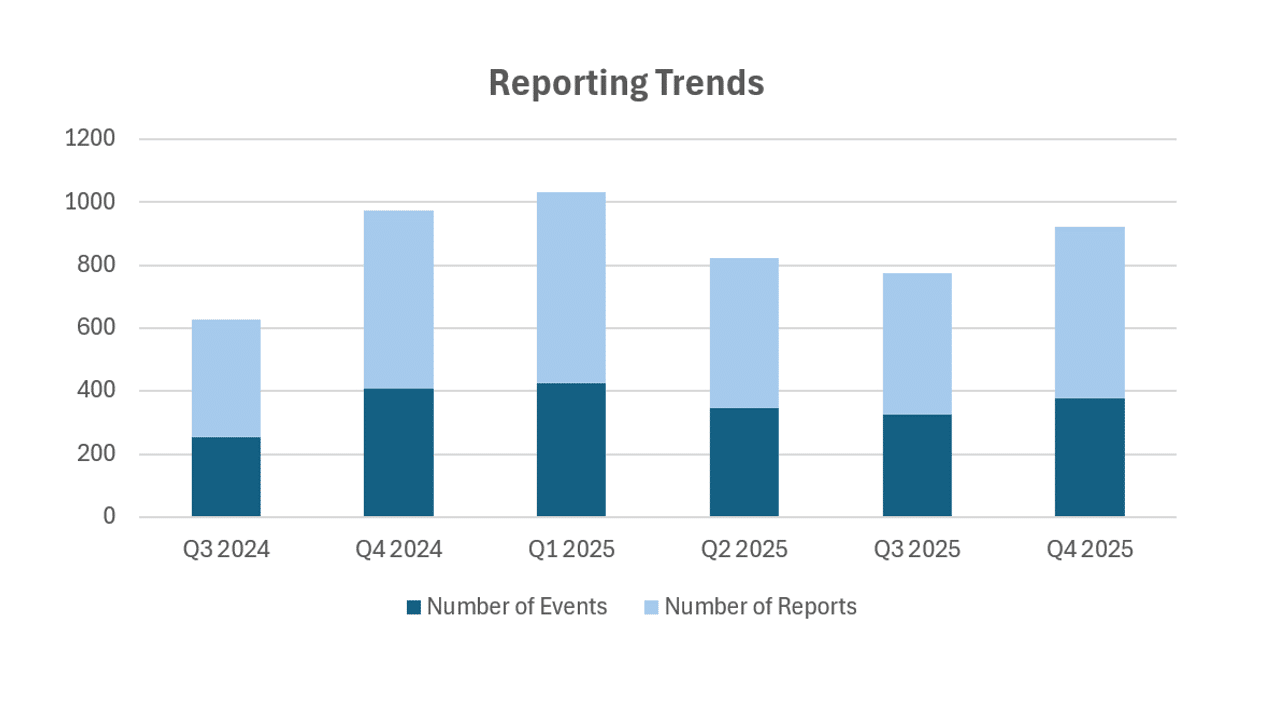
Reporting Trends
Reporting trends remain predicable year-to-year, with increase in submissions during FY Q4 and Q1 (October to March), driven by higher traffic volume and seasonal weather impacts. This, in conjunction with observations during ERC meetings, indicates a good reporting culture by our members, not just increased risk. The trend is consistent with implementation of mitigations and corrective actions. Again, we will continue to monitor the reporting rate trend to ensure it remains indicative of solid mitigation efforts versus underreporting of events. The gap between number or reports and events is due to multiple reports capturing a single event from different perspectives, further highlighting a positive reporting culture.
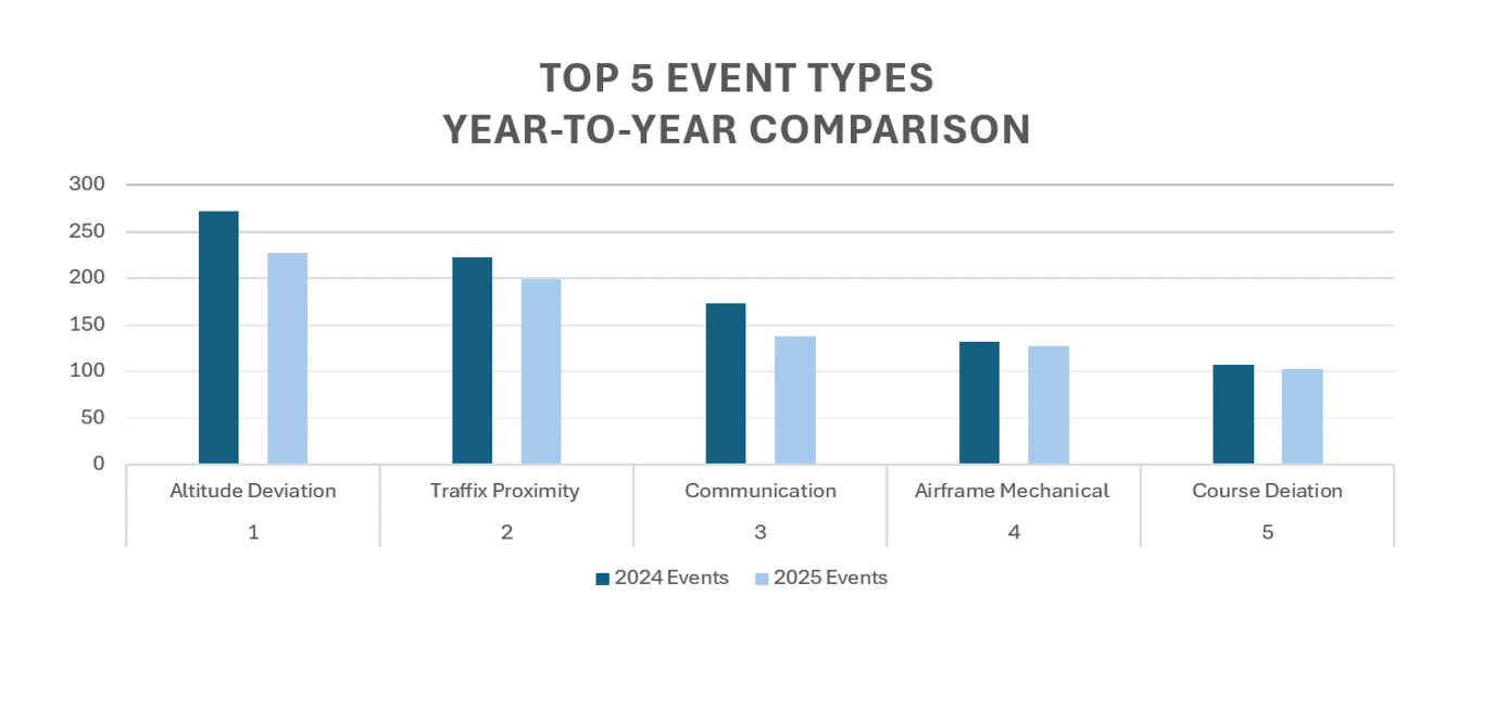
The data shows a consistent reduction in all five most frequent event types. The proportional decline across human factors driven categories indicates effective safety mitigations and corrective actions
General Aviation
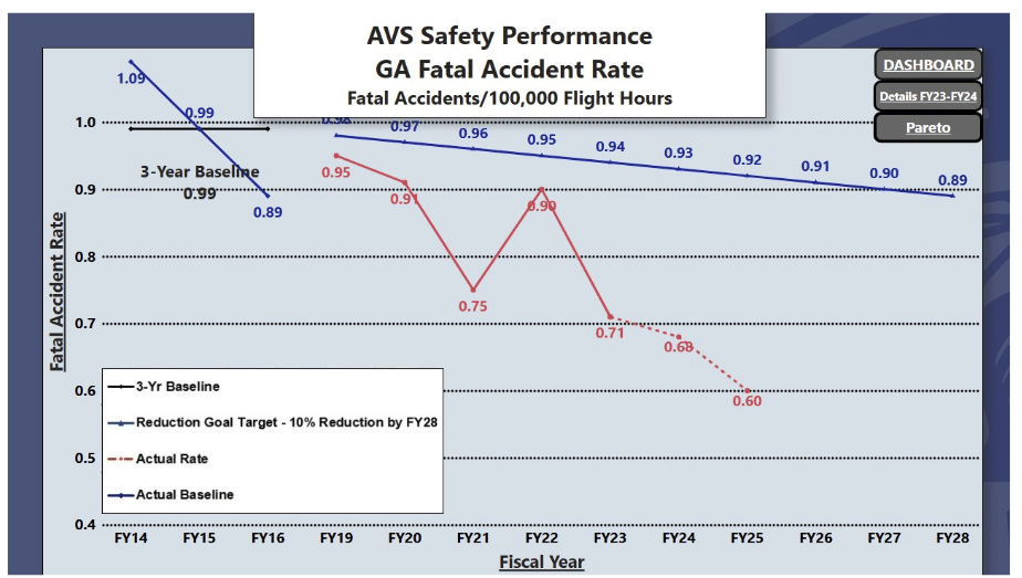
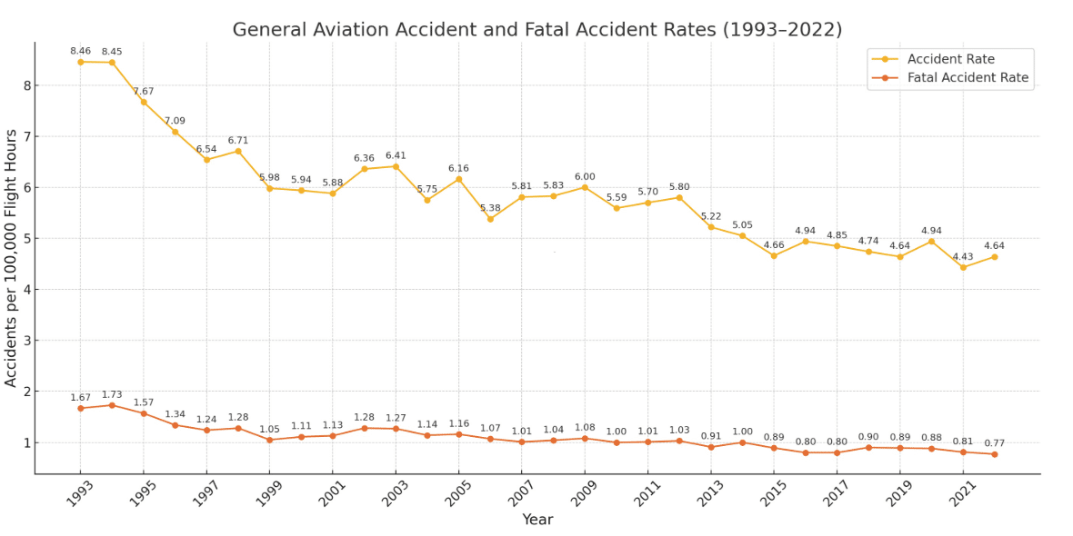
The available data for U.S. General Aviation shows a steady decline of accidents over the long term. Over the past three decades, both overall accident rates and fatal accident rates per 100,000 flight hours have trended downward, suggesting improvements in training, safety programs, risk awareness, and aircraft reliability. The AVS Safety Performance chart further demonstrates that GA accident rate is tracking below the predicted three-year baseline and head of the FAA’s long-term reduction target. However, fatal accidents still occur. It is important to note that historically GA fatal accidents are disproportionately associated with human factors: loss of control, weather encounters, low-altitude maneuvering, and decision-making errors. This explains why improvements occur gradually and why isolated spikes still appear despite overall positive progress.
AOPA Air Safety Institute Findings
GA Accident and Fatal Accident Rate (1993-2022)
Commercial Aviation
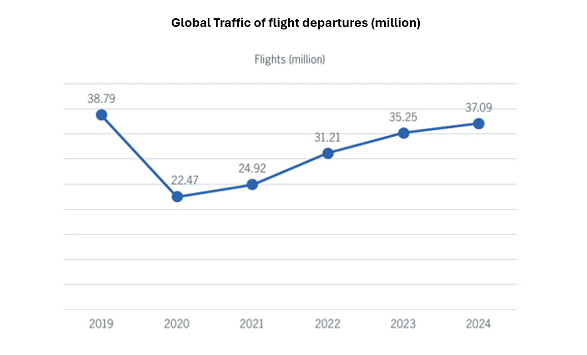
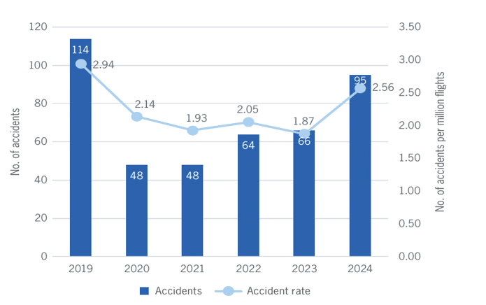
The most complete and available data for global Commercial Aviation is currently available up to 2024. This data shows a near full recovery to pre-2020 operations without proportional degradation of risk. 2024 accident rate of 2.56 per million departures is higher than previous few years, but remains below the 2019 pre-pandemic baseline of 2.94, suggesting that overall safety performance has been preserved despite increasing demand.
Global accident rates (per million departures)
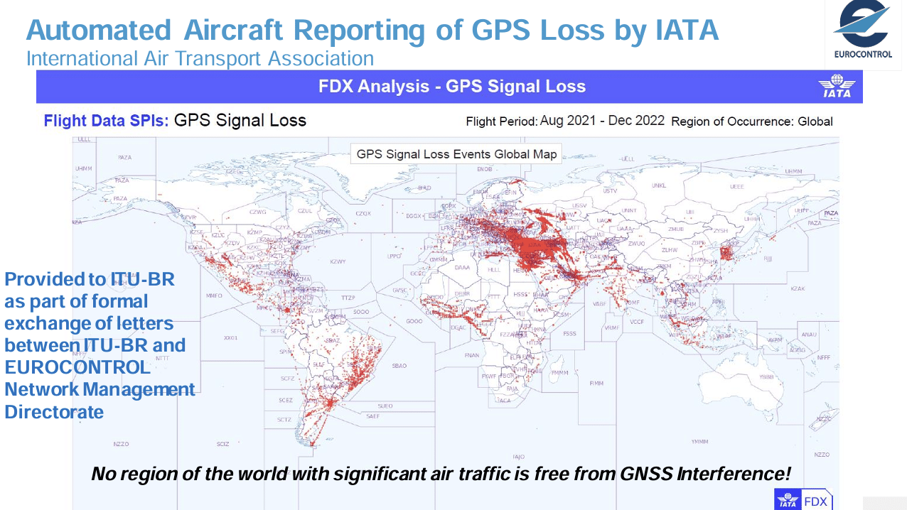
GPS / GNSS Interference
For the short term, it is not foreseen that the issue of the GNSS RFI can be fully resolved. Hence, efforts are being focused on mitigation. ICAO, FAA and other international organizations have identified several actions and measures to mitigate the impact and likelihood of GNSS RFI. ICAO is working on developing further guidance on spoofing as well as updating the Performance-based Navigation (PBN) Manual to better address GNSS disruption and implement PBN when GNSS is not available. The mid- to long – term solutions include the use of GNSS data authentication to enhance resilience toward GNSS spoofing, and redefining alternative position navigation and timing (A-PNT) technology and complementary position navigation and timing (C-PNT) to build resilient navigation.
Civil and Military Cooperation
Traditional civil–military airspace segregation has often led to inefficient routing and underutilized capacity. As airspace complexity increases, strong civil–military integration will be critical to enabling Free Route Airspace (FRA), unmanned aircraft systems (UAS) integration, and advanced air mobility (AAM). With the growing presence of drones and space operations, civil–military partnerships are essential to balancing safety, efficiency, and sovereignty in the future global airspace system.
In response, ICAO promotes a dynamic, demand-driven airspace management model based on real-time operational needs rather than permanent allocation. Central to this approach is the Flexible Use of Airspace (FUA) concept, which enables the temporary sharing of military airspace with civil traffic through structured information exchange and joint planning. This improves capacity and efficiency while fully preserving national security requirements.
The Evolution of Aeronautical Meteorological Service
Enhancing Aviation Safety Against Turbulence Encounters
The ICAO Fourteenth Air Navigation Conference recognized turbulence encounters as a major contributor to accidents and incidents. Importantly, it noted scientific evidence indicating a likely increase in the frequency and intensity of clear air turbulence due to climate changes and strengthening jet streams.
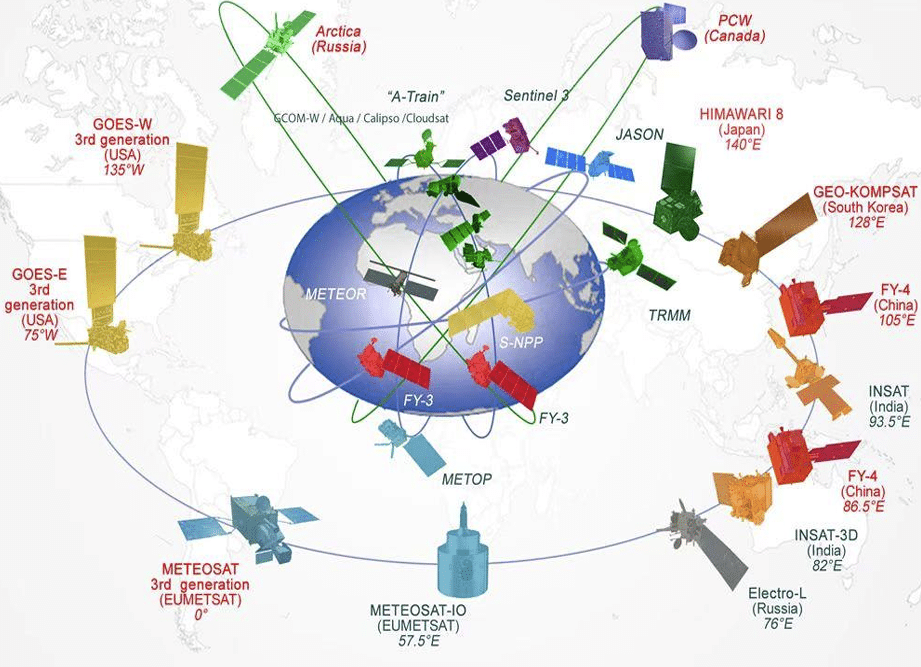
Recent technological advances in meteorology, including deployment of a new generation of meteorological satellites (GOES-S, FY-4, and Meteosat) are enhancing the quality and timeliness of aeronautical meteorological information. Industry initiatives such as the International Air Transport Association Turbulence Aware Platform demonstrate the safety benefits of collective turbulence monitoring. Further enhancement is expected through the evolution of the World Area Forecast System (WAFS), operated by the World Area Forecast Centers in London and Washington. As of November 2025, next-generation WAFS products provide higher-resolution forecasts of en-route hazardous weather, including separate probabilistic forecasts for clear air and mountain-induced turbulence. These advancements will aid in turbulence forecasting and assist decision-making across all spectrums, including flight operations, flight planning, and air traffic management.
REFERENCES
FAA Drone Sightings Near Airports
https://www.faa.gov/uas/resources/public_records/uas_sightings_report
FAA SAFO GPS/GNSS disruptions
FAA Unmanned Aircraft Systems Detection and Mitigation Systems
General Aviation Safety Fact Sheet, May 1, 2025
https://www.faa.gov/newsroom/fact_sheet/2025_General_Aviation_Safety_Fact_Sheet.pdf
General Aviation Joint Safety Committee (GAJSC) Fly Safe Flyer
Vol. 2, No.3 Summer 2025
AOPA Air Safety Institute 35th Richard G. McSpadden Report.
ICAO Safety Report 2025 Edition
https://www.icao.int/sites/default/files/spfiles/safety/Documents/ICAO_SR_2025.pdf